Sunday, September 18, 2011

Westward Ho- Bucket List roads pt.3

When I last left you, I had just arrived at my sister Kathy's home in Modesto. As usual it was hot in the Central Valley which in fact is not unusual this time of the year. The next day, I think, we headed down to Castle AFB and the museum located outside of the former front gate. I don't believe that I have been in California on visits that I have not visited their museum. As you may recognize, the pictures are of aircraft in that museum. I did include a shot of a flower in our wild flower garden just to show a little color. Next is a B-52D just like the ones that I used to work on and flew on a few times.


To the left is the casing of a hydrogen bomb, if blown up- the picture not the bomb- you may be able to read the plaque that gives some description. Below is a picture of a B-36 with that bomb casing next to the aircraft and people under the wing to give you some idea of scale.


Here is one of an addition of several Naval aircraft that have been added since the last time I was there. Below is some nose art on a B-29. After spending some time there, Kathy and I went for lunch at a cafe in Turlock which has been there for a long time and had a pleasant lunch. That was about all of the touring that we did while I was there. We did go shopping one day for some items for the house, like a new coffee pot and a repair item for the bathroom. I knew that it would happen, but after a couple of days I was struck by there usual case of "get home itis". I can wander for days leaving home and Jan particularly, but turn the corner and I would ride 24 hours a day to get home, if I could. I was out of Modesto at O dark 30, maybe around 5am and through Sacramento before the sun was up. After clearing Donner Pass and Reno it is pretty much just setting the cruise at 80 or so and hanging on until the next fuel stop. I stopped the first night in Wendover and returning from rounding up supper I heard the sound of a big radial engine aircraft. The sound of an R2800 prop plane is distinctive and saw a WWII Corsair make a low level pass at the old airfield right on the edge of town. This is the field where they trained to drop the a-bomb in WWII. Anyhow, I was out across the Salt Lake desert before daylight, through Salt Lake and on into Wyoming by early morning. I got caught in a rain storm, the first of the trip, in Cheyenne and made it to Kimball, Nebraska for the night. The next morning was an early start to try and make as much mileage as possible before it got too hot. I did not really get into real heat until about Lincoln and from then on all of the way home it was HOT. I took the wrong interstate through Omaha and ended up in Council Bluffs looking for the correct road. I ended up coming cross country through Spencer, Iowa to home by about supper time I believe. One thing I discovered on this trip was the importance of regular meals and keeping hydrated in the heat. I have been wearing a camel back pack lately that I pack full of ice when I stop at McDonalds etc., this gives me ice cold water for several hours that I can sip while I'm driving. This concludes my tale of what may probably be my last bike trip to the west coast, it is getting too expensive to spend that many nights in motels etc. etc.. This is not to say that I could drive back some time. Well, lots of other things have been going on here too, but that is another story. So long for now.




Tuesday, September 13, 2011

Westward Ho- Bucket List Roads pt. 2


I last left you at Lewiston, Idaho where I spent the night. Actually I was in Clarkston, Washington, but it is one solid city, and I never did see a state line marker. The pictures above are of Mount Shasta, and Mount Lassen, I think, Lassen I am not sure of. Anyhow, from Clarkston I made a loop through southeastern Washington to Walla Walla. In one small town in that loop was the most attractive county court house square that I have seen in some time. I never did stop to take a picture although I did consider it. When I am trying to make time I very seldom stop to take pictures even though I regret it later.
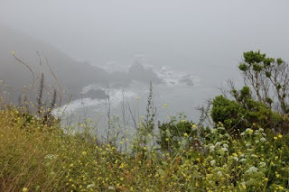
The picture above is from the afternoon that I finally got to the coast near Fort Bragg, but I will get to that in due time. From Walla Walla I ran down to Pendelton- I just noticed that there are a lot of cities names that end in ton in this area-. At Pendelton I picked up highway 395. This road runs all of the way down to the L.A. area I think. The ride from Pendelton down to Burns, Oregon was a pleasant surprise. I expected for the most part that this route would be mostly open country, but it was mountain ranges and green valleys. From Burns south to Lakeview, Oregon it was open country with very little traffic. I passed by Lake Abert which is 20 miles long and 7 miles wide. On the highway side of this lake is a very high cliff of volcanic rock. Some pieces, as big as houses are in the lake off shore, which means that at some time in the past they fell off of the cliff and rolled that far. I would have liked to have seen that- from a ways away, of course. I spent that night in Lakeview, Oregon, a very nice town not far from Goose Lake which is mostly in California. The trip across northern California was chosen for it's crooked roads, and I came to regret that route choice after a few hours of very crooked roads and traffic. Coming through Redding it was in the 100s again and the worst roads were ahead of me yet. I had been on highway 299 for most of the day but thought that 36 looked like a shortcut to the coast, big mistake. I thought that 299 was bad, but 36 was crookeder yet, in places it was so narrow it did not have a center line. I finally got out to highway 101 which is a 4 lane for most of it's length. Heading south on 101 occasionally it would neck down to a 2 lane and plunge through a redwood grove, very unique. I was on 101 until I hit highway 1 at Leggett, then it was out to the coast. That night was in Fort Bragg. The next morning dawned cool and foggy, about normal on the coast, I think. The run down to Bodega bay was part good, running through eucalyptus and redwood groves, and part bad. In places the road, which is not that wide to start with had lost a lane to slides into the ocean, which is hundreds of feet below. Some of the corners crossing creeks at the bottom of a grade had me in first gear looking up over my head at the road around the corner. I know that it is kind of hard to picture, but trust me it works. I had intended to cross the Golden Gate into San Francisco, but after that morning I thought better of fighting that much traffic just for the thrill of it. So I headed inland through Petaluma, Fairfield, to Lodi and down 99 to Modesto to my sister Kathy's home. I think that I will call it a day here and pick up part 3 when I feel up to more 2 finger typing. Stay tuned faithful reader, whom ever you are.